2. JesterMap Program
2.1. Distribution Package
JesterMap can only run on a Microsoft Windows system. It is distributed as a .zip archive with the following content:
bin |
Folder contains the program (JesterMap.exe) and supporting files. |
Sample |
Sample event, with both input and output files. |
html |
Documentation (open index.html for documentation). |
RunJesterMap.bat |
Sample batch file for running the program. |
The archive should be unzipped and placed in a convenient folder for use. The progam does not need to be installed.
Event files are best placed in a separate folder.
2.2. Running JesterMap
To run the program execute the command:
JesterMap.exe [-u] <event folder>
Where <bin folder> is the path to the executable and the <event folder> is a path to the folder containing the three event files. The option -u is not normally needed and can be omitted, see below.
For example, if the event files are in C:/Event then the command would be:
JesterMap.exe C:/Event
Note
Since this is not an ‘installed’ program you will need to add JesterMap.exe to the command path, or give the full path to the program, e.g. C:/Users/Me/Program Files/JesterMap/bin/JesterMap.exe. If the path to the event folder has embedded spaces it must be enclosed in quotes.
The RunJesterMap.bat file may be a convenient way of running the program - edit it to include the correct path for the program. The event folder can then be dragged and dropped onto RunJesterMap.bat to create a map file.
The output map file is named <event name><date & time>.kmz and is created in the event folder. The event name is specified in the event configuration (see below) and the date and time in the file name avoids overwriting previous maps. This file can be opened directly in Google Earth or in Google My Maps. The necessary icons are embedded within the file.
The program also writes a log to the console, and appends the same information to a jester.log file in the event directory. The log from every run includes the most recent recorded position for every boat:
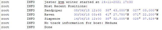
The log will warn if there are positions recorded for boats which are not in the boats configuration file, or if boats present in the configuration have not reported any positions, as above.
The log will also warn if any fields (e.g. date, position) cannot be decoded, together with the number of the line with the error. In the following example, longitude is missing in the position:

Lines with errors of this sort are discarded so the log should always be checked to ensure there are no such errors. Format errors may be caused by formatting inserted or modified by a spreadsheet program; it can sometimes be necessary to correct such errors in a basic text editor. See below for more information about accepted formats.
2.2.1. Option -u
This option switches the input format from the normal local Windows encoding to Unicode UTF-8.
Normally this option is not required, and should be avoided if the input files are created using Excel. If the input files are prepared on a non-Windows computer (Linux or Mac) then they should be saved as UTF-8 and can then be read using the -u option.
The other case in which Unicode input is justified is if a wide range of international characters is required. The default windows encoding is able to accommodate most European characters and symbols such as degree, but if a wider set of international characters is required then the input files need to be saved and read as UTF-8.